
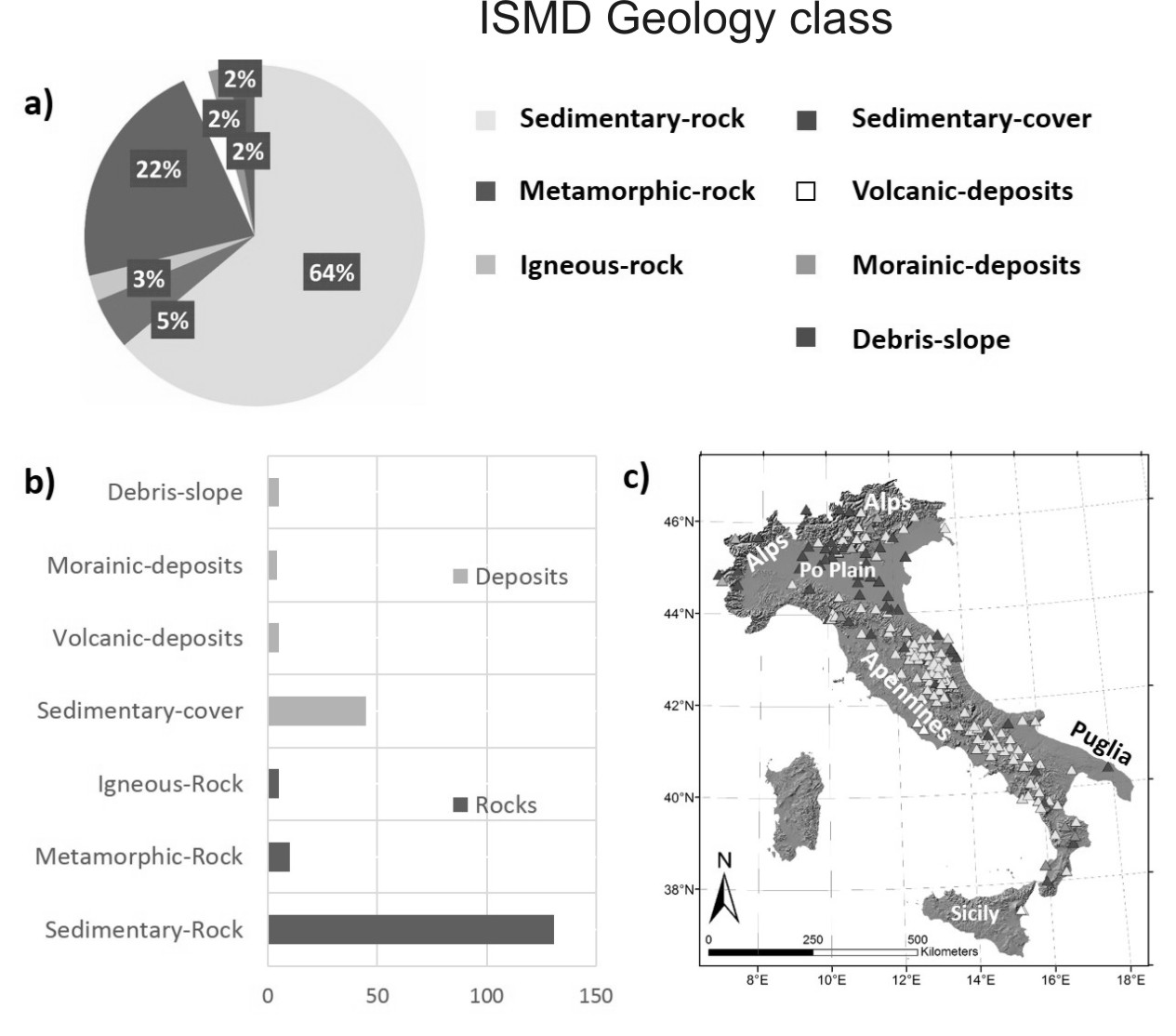
GEOLOGY
For each recording site, the geological map at scale 1:100.000 (Italian Geological Maps) is provided with topographic IGM base at scale 1:25.000.
If available, also detailed geological maps at scales 1:50.000 (CARG project) and/or 1:10.000 are provided.
Considering the geology, all recording stations are grouped following the example.
MORPHOLOGY
For ech recording site is available:
- the Digital Elevation Model (DEM);
- the 3D screenshot from Google Earth, with elevation increased three times to emphasize the geomorphology;
- the Slope Map with ridges. The slope classes are defined considering the topographic classification indicated by the Eurocode8 (CEN, 2003) and the Italian seismic code for building (Norme Tecniche per le Costruzioni, NTC-2008; 2018);
The DEM used for the analyzes is a 1 degree resolution Global Digital Elevation Model (ASTER GDEM V2), downloaded from the web site http://gdex.cr.usgs.gov/gdex/.
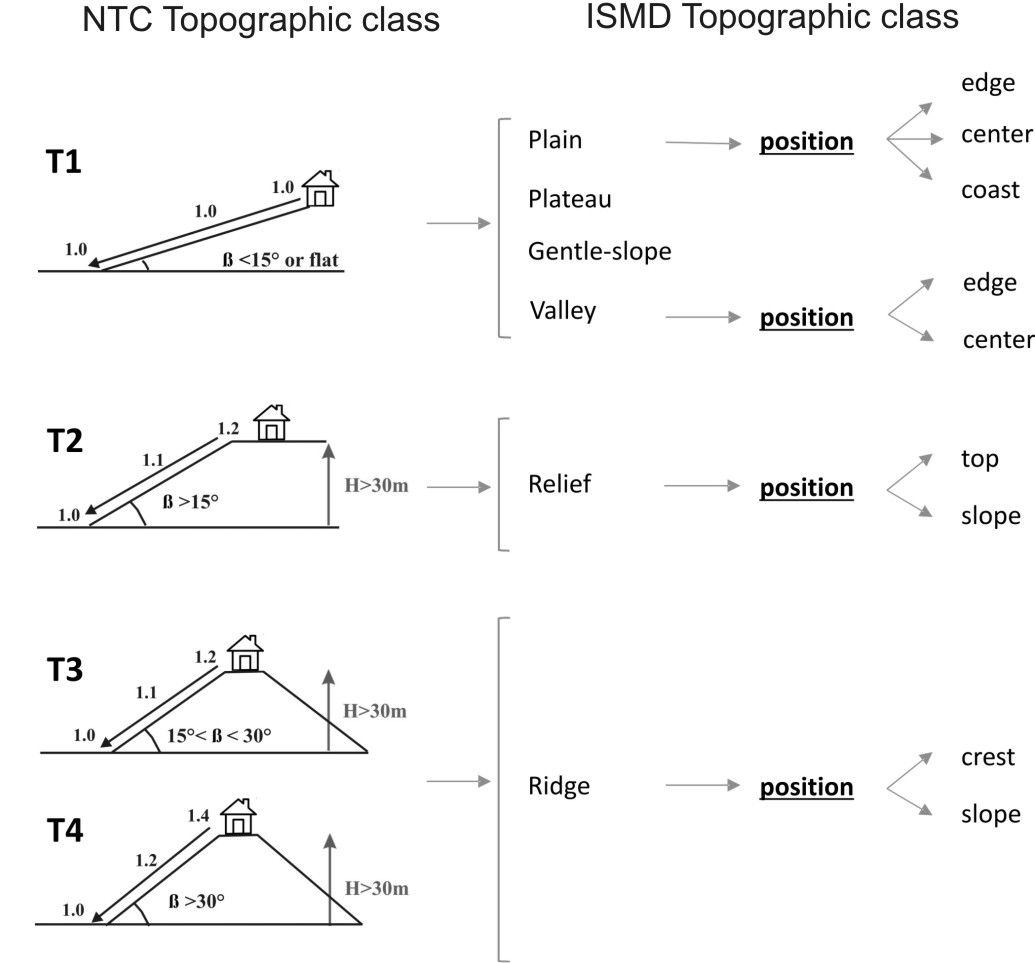
Considering the topography, all recording stations are grouped following the example.
GEOPHYSICS
The analyzes were performed considering:
- enlarged band (Lennartz 5s) or broad band (Trillium 40s) velocimeters. If only accelerometric measures are available the results are missing. They will be provided as soon as velocimetric measures will be performed;
- duration from 2 hours (at least 120 windows of 60 s) to 24 hours;
- window lenghts of 60 seconds. Except in cases of very low frequency peaks (<0.4 Hz), where 120 seconds windows were preferred;
- tapering 5%;
- Konno & Omachi (1998) smoothing with b=20.
For each recording site are available:
- the Fourier spectra (not filtered);
- the HVSR (horizontal to vertical spetral ratio), calculated considering the ratio between the quadratic mean of the two horizontal components and the vertical one;
- the directional HVSR;
- the preliminary indication of the fundamental frequency (f0).
The f0 value is provided considering the results of the microtremor HVSR, together with the geological and the geomorphological conditions of the site. Usually f0 corresponds to the lowest frequency peak with amplification (A)≥2. In case of multiple peaks in a broad range of frequencies, the value of f0 is selected based an expert judgment.
f0 'none' indicates a flat response of the noise HVSR (A≤2) in the frequency range 0.1-10 Hz.
If available, also the dispersion curves and the shear waves velocity profiles (Vs) are provided, togheter the Vs30 (see NTC-2008) or Vs,eq (see NTC-2018) value desumed from the Vs profile or others references.
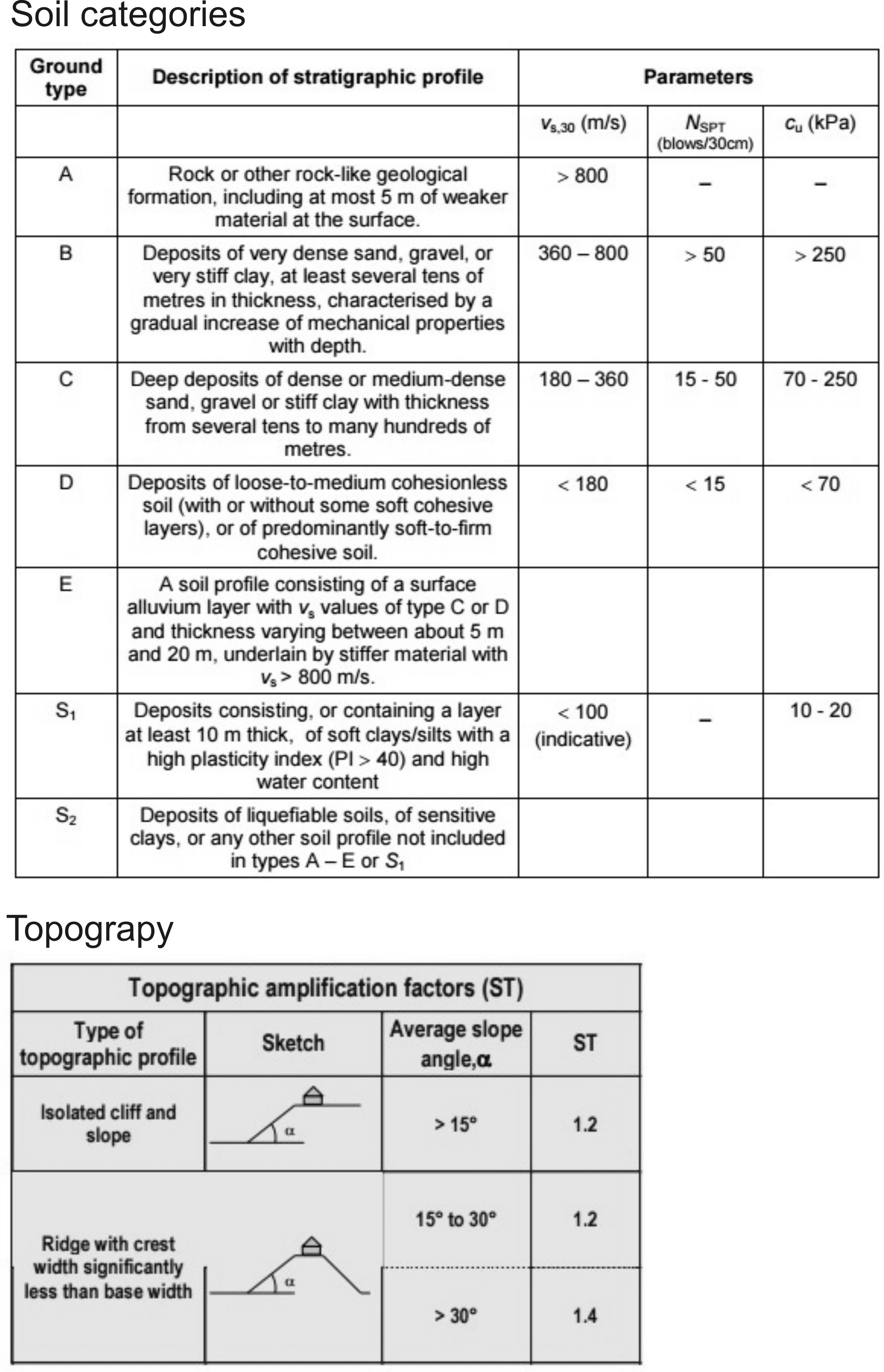
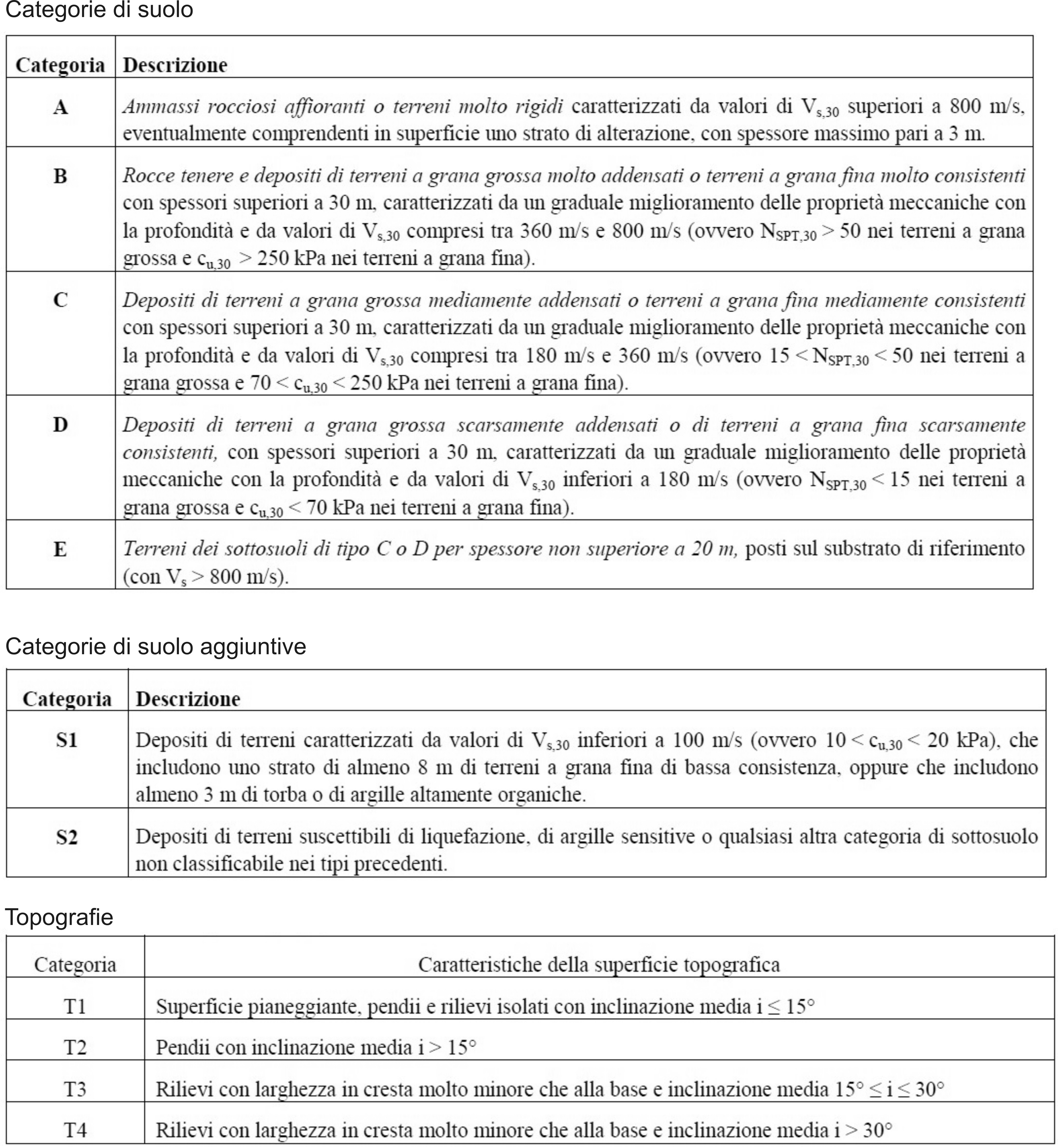
SEISMIC RUGULATIONS
For each recording site both the soil and the topographic categories, are provided following the Eurocode8 (CEN, 2003) and the 2008 Italian seismic code for building (NTC-2008) or (if possible) the new 2018 Italian seismic code for building (NTC-2018).
- Soil Class: the symbol * indicates that the classification is only based on the available geological information. The changes with respect to the reference classification (Di Capua et al., 2011) are indicated with the symbol **.
- Topographic Class: in a first stage, the semi-automatic method proposed by Pessina & Fiorini (2014) is used, considering a buffer with a 100 m ray. In a second stage, the classification is corrected measuring the average slope on Google Earth. The sites not classified with the semi-automatic method (NC output) are indicated with the symbol *, whereas the changes after the Google Earth control are indicated with the simbol **.
For information about data providers see networks (FDSN)
For more details about the site characterization see Mascandola et al. (2018)
For further information mail to [javascript protected email address]
© 2024 ISMD: INGV Strong Motion Data web portal |  CITATION | COOKIE & PRIVACY | DISCLAIMER | CREDITS | CONTACTS |